Showing posts with label Kamaran. Show all posts

Monday, 28 September 2020

1744. 🇰🇮 Bye-ways Of Empire - Canton Island.


🇰🇮 In Blog 523 I reported that I had discovered lying buried deep in the swamp of my ignorance as well as the the obscure pages of Wikipedia, a former British territory of rather uncertain political status which sat off the coast of Yemen and which was eventually incorporated in the newly independent South Yemen and which went by the name of Kamaran. It definitely qualified to be considered to have been situated down one of the “Bye-ways of Commonwealth stamp collecting”.
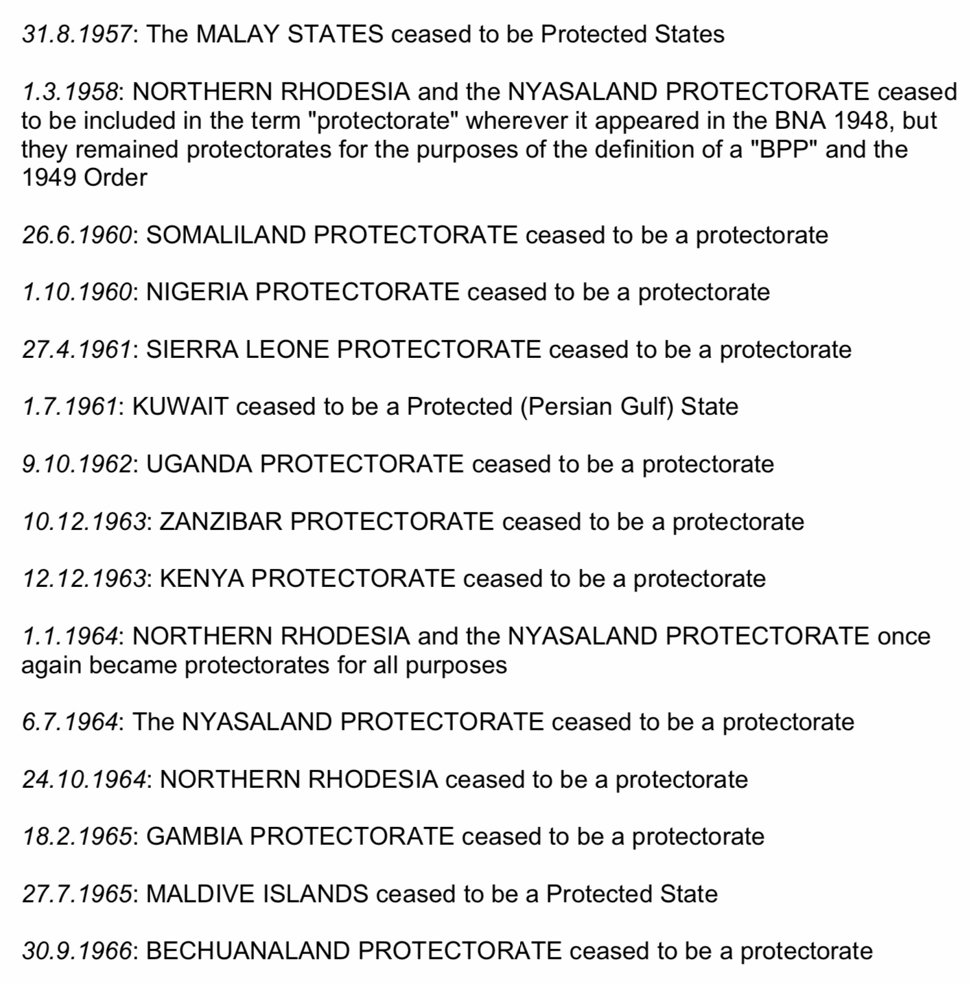
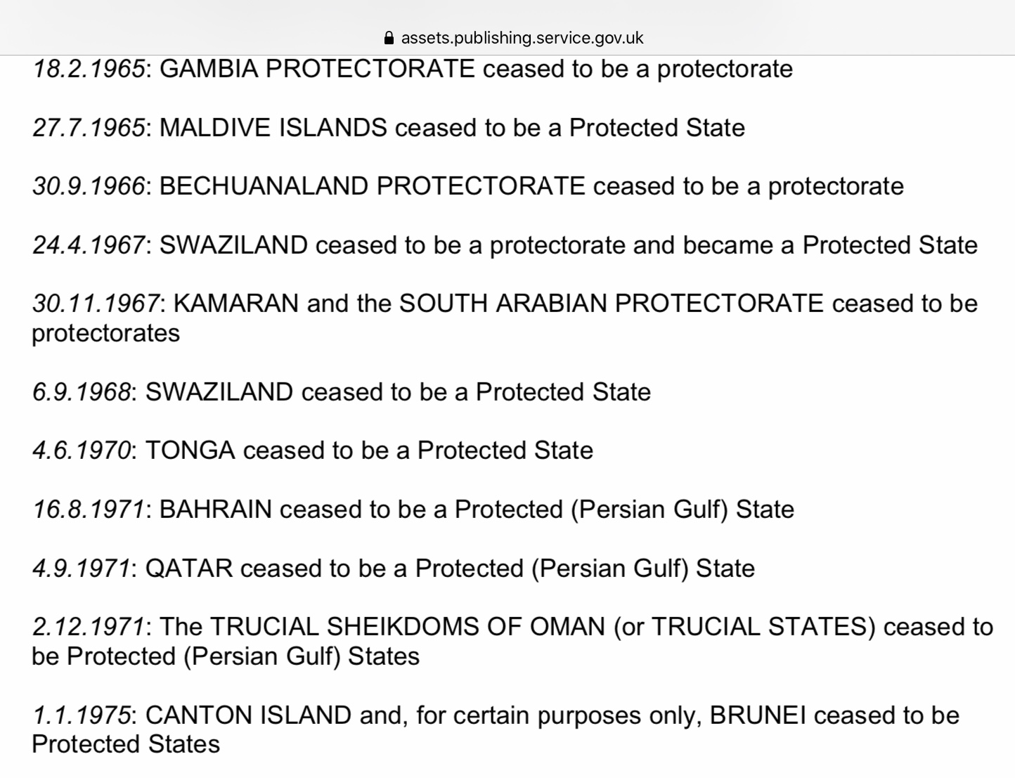
  Kamaran eventually qualified to be called a British Protectorate from January 1954 until 30 November 1967. The status of various former British colonies, protectorates and protected states is not just of academic interest but has practical implications for inhabitants and their descendants who lived there because they may or may not be entitled to British passports of one type or another. While doing a little more research about Kamaran I came across the official list of Protectorates which is shown below. The names of these places ought to be fully familiar to me but one stood out - a place I’ve heard of and seen featured once or twice on Kiribati stamps but never really took much notice of. But here it was - a Protected State in its own right - Canton Island, to which the British had initially laid claim as long ago as the 1850s.




  Canton Island, now Kanton Island, is the largest, most northerly and only populated island in the Phoenix Island Group which is part of The Republic of Kiribati. The only village on Kanton is Tebaranga and the island’s population in May 2010 was just 24. The island is surrounded by the vast area of sea named in 2006 as the Phoenix Islands Protected area, a large marine reserve containing 8 atolls. The Kiribati postal service commemorated the establishment of the marine park by issuing a set of 6 stamps and 1 miniature sheet containing all 6 stamps on 12 July 2008 and one of them depicted a map of Kanton Island (shown above) and another a map of the whole reserve (below).


  The first recorded European visit to Canton Island was by two British whaling ships, the Phoenix and the Mary, on 5 August 1824 under the command of Captains John Palmer and Edward Reed. The island was initially named Mary Ballcout’s Island after the shipowner’s wife but then given the name Canton in 1854 when the New Bedford whaling ship of the same name ran aground on the atoll.
  The British paid several visits to Canton Island subsequently and claimed sovereignty over the island in the 1850s and the British claim was reasserted on 6 August 1936. The British established a radio station there but prior to that American and New Zealand scientists landed on the island to observe a total eclipse of the sun. The American party claimed the island for The United States and erected a monument with two USA flags. It is said that a Royal Nay vessel HMS Wellington fired a shot across the bows of USS Avocet because the Americans had grabbed the best anchoring point and the Americans returned the shot. The two captains then held back until they received their governments’ instructions and the result was restraint to allow the scientific teams to carry out the observation of the eclipse together although  relations were somewhat cool.
  More Americans landed on Canton in March 1938 and US President Roosevelt placed the island under the control of the US Interior Department on 3 March 1938. The competing claims were resolved when both governments agreed to establish a Condominion over Canton on 6 April 1939. This was known as Canton and Enderbury Islands Condominion. The British were used to Condominions - they already shared joint rule in Sudan with Egypt and in the New Hebrides with France.
  Anglo-Egyptian Sudan had a single post office but New Hebrides had both a British and French post office and local inhabitants could choose to use whichever of the two postal services they preferred but The Condominion of Canton did not have its own its own postal service and it was not until 1939 that a post office was opened there. 
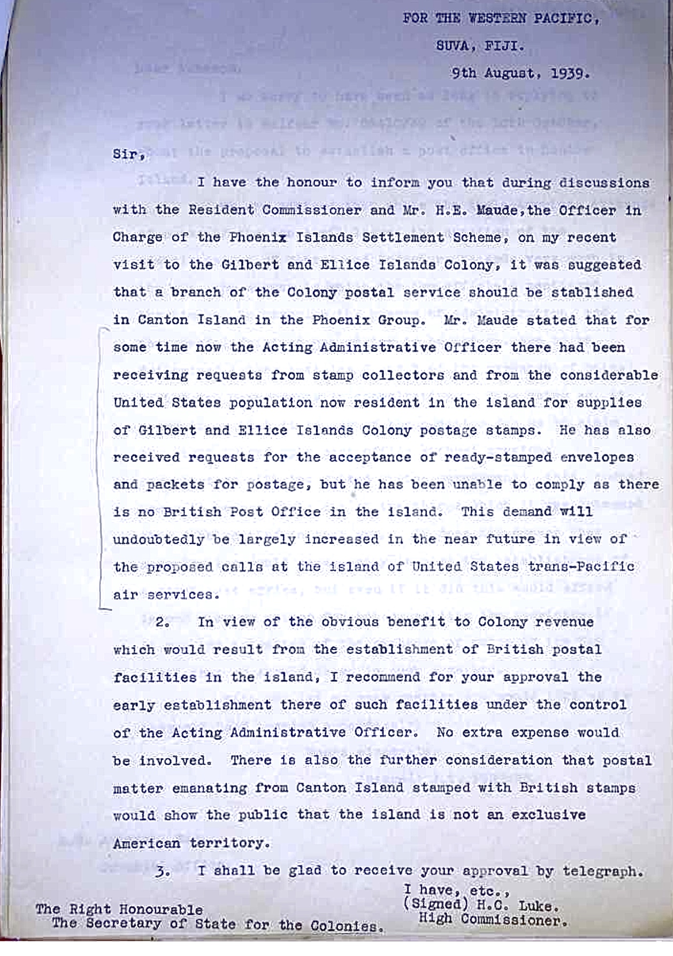
  I found a letter on the internet, though I can not see whom to credit for its posting there, of a letter from the British High Commissioner for the Western Pacific, whose area of responsibility included the Gilbert And Ellice Islands from where The Phoenix Islands were administered, written to the Secretary of State for the Colonies in London asking for his approval for the establishment of a British post office on Canton. He reports that the government administrator on Canton had been receiving requests from stamp collectors for supplies of Gilbert and Ellice Islands stamps from the island as well as requests for the acceptance of ready stamped envelopes and packages for postage but he was unable to oblige as there was no post office on the island. The Western Pacific Commissioner described two means by which the opening of a post office would benefit the British administration by the opening of a post office - a gain from the revenues flowing from stamp sales and the assertion of Britain’s sovereignty in the face of the American claims on the island.A fascinating letter. Perhaps the Western Pacific Commissioner missed a potential additional source of financial gain - the production of individual stamps for the Canton Island Protectorate.
  The US administration opened a post office on Canton in 1941.


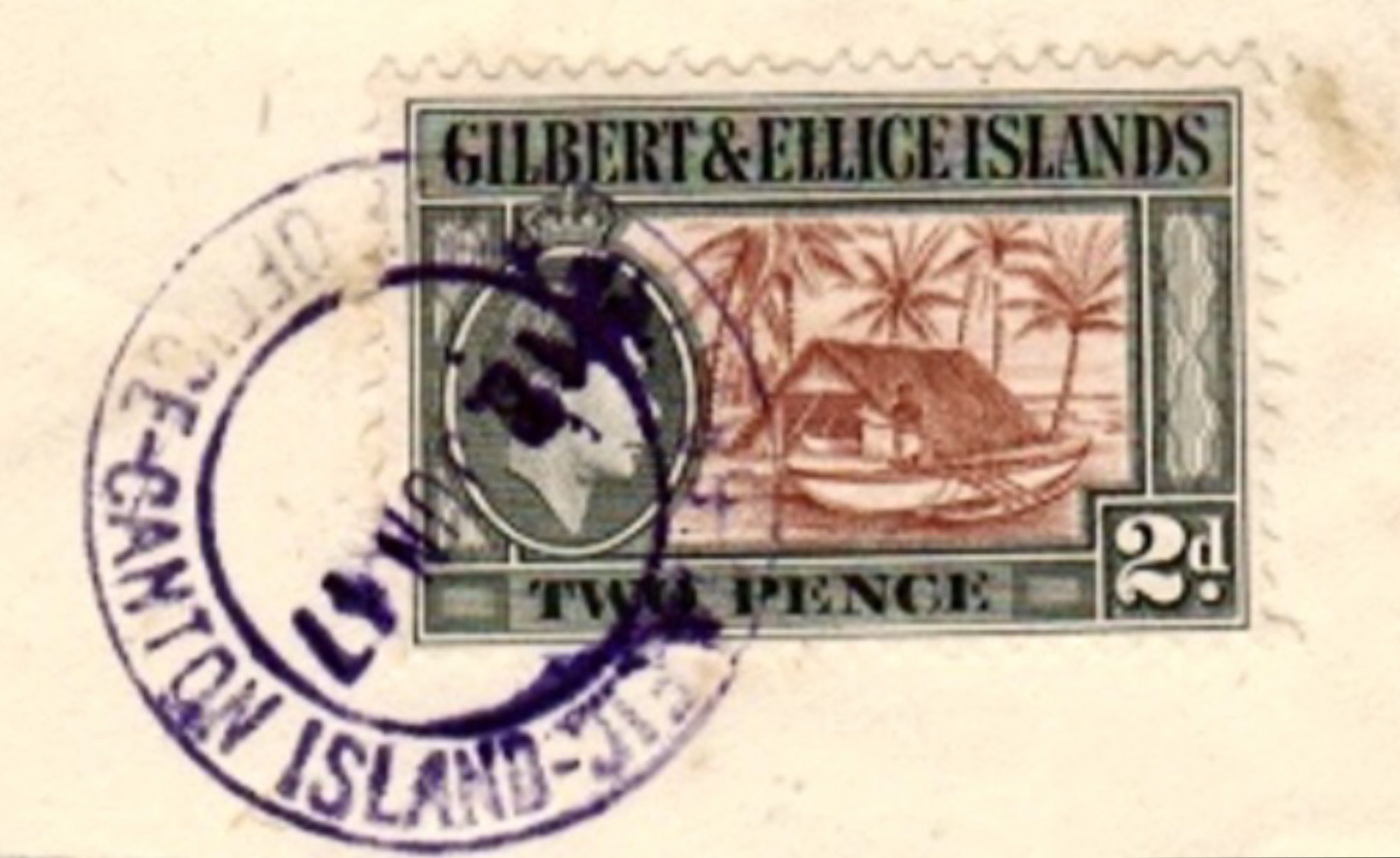
The geographical position of Canton proved to be of the utmost importance in the island’s development. Pan American Airways built facilities for a planned New Zealand flying boat service and the service began on 12 July 1940. When the Americans finally joined the United Kingdom in participating in the Second World War the US Navy built an airstrip on Canton Island as a stopover for flights to Australia and New Zealand and as a staging post for attacks on the Japanese forces occupying the Gilbert Islands. Canton was defended by 1200 troops but was not attacked by the Japanese. After the end of the war several airlines began services which flew across the Pacific Ocean stopping at Canton Island. A community was established on the island to service these flights and to support the airport workers - the island was thus home to an electrical power station, a school for workers’ children, a hotel for aircraft passengers stopping over and other necessary facilities. Eventually the introduction of long range aircraft reduced the need for a refuelling station on Canton Island and by the late 1950s flights by all airlines but PanAm had ceased to use the island’s facilities. A large numbers of flight covers exist from this era in Canton Island’s history. Covers from the British post office dating to the 1950s are not hard to find but much less common than those associated with flights and from the US post office. It is clear that a number of the covers for sale with Gilbert and Ellice Islands stamps fixed to them are philatelic in nature but they are generally interesting and visually attractive.
 The Condominion continued in a generally cooperative fashion and the British and American post offices on the island were housed in the same building. With the loss of aircraft traffic the Canton Island community continued to be able exist with the establishment of a tracking station for the US Mercury space programme from 1960 to 1965. The US Airforce and the US Space and Missile Systems Organisation used the island as a base for missile tracking operations until 1976 when all American personnel were withdrawn from the island. The British post office was also closed in February 1968 but the US post office stayed open until 1979  when the Condominion ended and Canton Island and the other Phoenix islands were included in the Republic of Kiribati when it was granted independence in 1979.


Saturday, 14 March 2015

523. Bye-ways of Empire - Kamaran.


  With stamp collecting, every new day brings a surprise along with it. After decades of collecting stamps of the British Empire and Commonwealth, I have just discovered a territory which was once part of the British Empire but which I never knew to have existed up till now. It's name? - Kamaran.
  How did I come across this evidence of my ignorance? Yemen is said to be one of the countries which has applied for membership of The Commonwealth but the political situation there has deteriorated in recent months so that the country's president Abd Rabbuh Mansur Hadi, was forced to resign on 22 January 2015. The country's capital, Sana'a, had fallen to rebel Houthis in September 2014 leading to their takeover of the presidential palace which proved to be the event which precipitated the president's downfall.
   For a few days the country was without a president but the Houthis have now established a five man council which will rule in place of a president. This takeover of power in Sana'a may encourage the South Yemenis to split from the north and reestablish a republic in South Yemen which existed from 1967 until 1990 when the two Yemens formed a single state. Prior to its independence South Yemen was made up of a number of territories under British protection including the British colony of Aden. The area has a fascinating philatelic history. 
  My reading about these current events made me think that I should include a set of the first issue of South Yemen in my collection of South Arabia just to provide a tidy ending to my collection since several philatelic entities - The Federation of South Arabia, Kathiri State of Seiyun, Qu'aiti State of Shihr and Mukalla and The Mahra Sultanate of Qishn and Socotra all ceased to exist at the same time (more or less) and were joined together in the new South Yemen. The first set of the People's Republic of Southern Yemen took the form of the former definitive series of The Federation of South Arabia with overprints applied in Arabic and English. The complete set was made up from 10 low values depicting the arms of the Federation and 4 values depicting the Federation flag in which the old colonial emblems were partially defaced by horizontal lines applied to the stamps:-


  While reading about these post-independence stamps I came across the name of the island of Kamaran which is 22 square miles in area and is part of a group of 10 small islands situated off the coast of Yemen and I was interested to read about its rather ambiguous status in the British Empire. Until 1915 Kamaran and its neighbouring islands were part of the Ottoman Empire until occupied during the First World War by British troops from Aden.
   In the 19th century, both the British and French had shown an interest in the island as a place from which to control the southern Red Sea but this eventually amounted to nothing more than the establishment of a telegraph station by the British on the island in 1860. The Ottomans established a quarantine station for Muslim pilgrims on their way to hajj in Mecca in 1882. As many as 40000 pilgrims passed through the island in a single season. Fighting took place on the island during the Turco-Italian War of 1911 to 1912.
  As written above, the British occupied Kamaran in 1915. It is said that the British seized the island less because it was an Ottoman possession but more to forestall any move there by the Italians, Britain's wartime allies. The RAF marked out a landing ground on the island in 1919. The Turks renounced all claims to Kamaran in the Treaty of Lausanne of 1923 but the future sovereignty of the island was not settled by the treaty. A planned international convention on Kamaran and the other Red Sea islands was never convened and so Britain, continuing its occupation, administered the quarantine station on behalf of the governments whose citizens used it.
  Kamaran whose status at this time must have been that of a territory (which belonged to no-one after 1923) under British occupation was administered for the government of British India by the Resident of Aden who appointed a resident civil administrator for Kamaran. The island's status and the wish to allay Italian suspicions of British militarisation in the area meant that only police from Aden and the South Arabian Protectorate could be used on the island. 
  In the early stages of World War 2 Kamaran served as a re-fuelling base for the Italian East Africa campaign. The war interrupted the hajj until 1944 when the quarantine station reopened and was used until 1952. As a result of India's achievement of independence, responsibility for the administration of Kamaran was moved from The Government of India to the Colonial Office in 1949. The title of the Civil Administrator was changed to Commissioner and he continued to be appointed by the Governor of Aden even though the island was not part of the Aden colony nor of the protectorate. The Order in Council defined the islands at that time by stating that the British Crown had "power and jurisdiction" over the islands.
  By the order in council of 1 January 1954, while the islands were not formally annexed, the island's citizens were given the status of that of British Protected Persons so that Kamaran became an informal protectorate. This status applied to its sister islands of Kadaman Kabir, Shab Bodinjan, Okban, Al Bodhi, Okban Saghir, Jureb, Risha and Arab Shoal.
  Yemen made claims to the sovereignty of Kamaran but British control of the island continued with a report of 1961 stating that the local population amounted to 1200 people who were impoverished. In November 1967 Kamaran was handed over to the new People's Republic of Southern Yemen but was captured and occupied by troops of the Yemen Arab Republic in October 1972 in a war between the 2 Yemens.
  An article on the Philatelic Experts website by G. Kock (2011) points out that the Turks provided a post office service on Kamaran for many years prior to the British occupation for the Hajj pilgrims even though the local population amounted to just about 100 people at the time.
 It is stated that an Indian Army Field Post Office operated in Kamaran from 1915 (the occupation took place around June 1915).
   There are a number of posts in Stampboards.com dating back to January 2009 by the author GJ50 which deal with the smaller post offices related to Aden including Kamaran. Two covers are depicted there which show the use of Indian stamps on Kamaran dated from 1925 and the author notes that a civilian post office was opened on the island in 1921. The illustrations show circular date stamps used between 1921 and 1937 when the Aden Post Office took over services on Kamaran (from which date the stamps of Aden were used on the island). Wikipedia states that Kamaran had a sub-post office of Aden from 1924.
  A piece titled Perim The Last Colonial Outpost by Peter Pickering and Ingleby Jefferson (2014) points out that the RAF made regular training flights to Perim and Kamaran from 1928 and to supplement an infrequent and irregular steamer service and the calls of the government vessel on the Aden Station, the RAF agreed to carry mail to the territory at ordinary postal rates. A weekly airmail service was established which was reduced to twice monthly after a couple of months and then continued, alternating with a sea-borne service from the Perim Coal Company until 1939 although the Perim sub-post office was closed on 1 October 1936. It seems that the mail aircraft flew out to Kamaran via Perim on one day and then returned to Aden, again via Perim, on the following day.
  I have just bought on an auction website an interesting cover which dates to 1968 and provides me with an early cover from The People's Republic of Southern Yemen and so provides me with a satisfying last page to my South Arabia collection (as I stated I should like to do in the 3rd paragraph of this piece) but, as it is cancelled Kamaran, also gives me an item related to a separate part of the British Empire which has been previously unrepresented in my collection. My cover has 2 South Yemen stamps of 1968 on it tied by a small KAMARAN circular date stamp "26 JU 68".
  Kamaran is one of those few politically separate territories which never had stamps produced for its specific use - in that respect it reminds me of Wei-Hai-Wei (see Blog of 28 December 2011), Akrotiri and Dhekelia (Blog 210) and the Protectorate of Witu. Most interesting though is the fact that this was a part of the British Empire which was in a sort of political limbo from 1923 when the Turks gave up any claim to sovereignty over it until 1954 when it became an informal British protectorate and even then its status was not fully clear until it was incorporated in Southern Yemen on 30 November 1967. It was rather as though it was a territory that the Colonial Office forgot that it had got.
  With stamp collecting, every day brings a new surprise along with it.


Flag Counter